

| Tuesday at a glance | |||
| Miles | 69.5 | 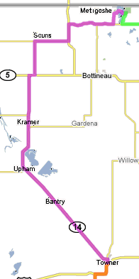 |
|
| Mph | 16.2 | ||
| Max Speed | 31.2 | ||
| Route | Towner to Lake Metigoshe State Park via Upham, Souris. | ||
| Wind | 10 mph from the south-southeast. | ||
| Temperature | upper 50s to upper 70s, with the latter after the fog dispersed around mile 55. | ||
| Elapsed Time | 4:16:20 | ||
| Clock Time | 6:40 - 11:50 | ||
Tuesday morning. It was pretty foggy outside the tent on what was supposed to be a sunny day. Maybe it'd burn off shortly. We were biking from the plains to the Turtle Mountains today. Given the flat terrain we'd be on most of the day, I was hoping to get some pictures of the hills on the horizon. The camera was coming along!
We got going at 6:40, a little earlier than normal because of the 70 miles ahead of us. The wind was sort of a tailwind starting out, and that helped move us along. At times the fog was dense enough that visibility was down to a hundred yards or so--not so great for sight seeing along the way! Once we left Towner, the next twenty miles were completed in just over an hour, and with no break in pedalling. We finally hit a (very) slight downhill and I asked Dad if we should stretch our legs. He agreed, so we coasted a few feet and started pedalling again. Upham, the first stop, came fuzzily into view a couple of miles later.
The stretch to the next stop at Kramer was relatively short--about ten miles. We were passing through some pretty prairie pothole country, and lamented the fact that the out-of-staters on the ride weren't able to see it in its full glory. Heck, we were lamenting the fact that we weren't able to see it either. The other thing we failed to see in time was the sign at Kramer pointing out the turn into the little town. We sailed passed and then stopped at the next intersection to figure out what to do. Some riders coming from the stop said that the caramel rolls were great and well worth the stop, but since we'd just snacked at Upham, we decided to keep rolling through the fog.
We both saw them coming up from behind. A paceline. For the speed they were
going, we expected them to blow by us, but they latched on instead. As the wind
was sort of at our backs, I didn't think we'd be making enough of a difference
for them, but the four of them hung on. We weren't particularly thrilled with
it as it took away some of the leisureliness of the ride for us ("Do we have to
pedal continuously?" "Can we slow down a bit to check out that...?"), but we
kept up our pace. It looked like the train was getting longer. We had a
slight jog in the route and could see even more riders behind us. We finally turned into
Souris, another rest stop, and several pulled up alongside us to let us know
how appreciative they were for the help. There was more praise at the rest
stop for us and "the red Cannondale." A couple of guys said that they were glad
Souris had come when it did because they were having problems hanging on. All
in all, we pulled at least ten riders into Souris. Any thoughts of animosity
had quickly disappeared. That afternoon and even a
couple of days later, some riders swung by the tent and said thanks. Dad and I
got a chuckle out of The Red Cannondale's reputation.
![]()
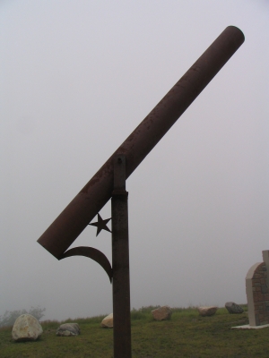
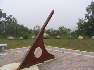 But, our few minutes of fame was over. Souris marked the start of The Climb into
the Turtle Mountains. It was still foggy and drizzly so we couldn't actually see
that there was now an uphill grade, but we sure weren't making the kind of time we
had coming into Souris. We headed east sort of into the wind, then north with
it, and then a right "up," into it again and the final climb of 700 feet. It
was work, and we could have used a lower gear on the tandem. I was about to
the point of needing to pull over before my legs totally gave out on me, when
we rounded a bend, and there was the entrance to the Mystical Horizons scenic
point. Given the weather, it was more Mistycal Horizons. It was the location
of the last rest stop, and a little off the main road. The climb was even
steeper, and the pavement broken up, so we bagged the riding and pushed the
tandem up the hill to the overlook with a great view of the prairie we'd just
left. Except all we saw was fog, which was rather disappointing. And, there
was the modern Stone Henge--a large sundial (doesn't account for Daylight
Savings time, the sign said
![]() ), a tube pointed toward the North Star, and
rocks and walls situated to mark the solstices and equinoxes. Dad had been
there before and played tour guide for a few riders, explaining what they
were seeing. All in all, it was worth the little hike up from the road, even
though the spectacular prairie view was hidden from us.
), a tube pointed toward the North Star, and
rocks and walls situated to mark the solstices and equinoxes. Dad had been
there before and played tour guide for a few riders, explaining what they
were seeing. All in all, it was worth the little hike up from the road, even
though the spectacular prairie view was hidden from us.
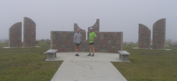
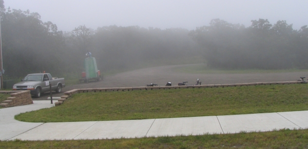
Our legs complained a bit when we got going, especially since we weren't quite to the top of the hill, but they loosened up. And then the sun came out! I guess it was better late than never, and it was during the prettiest part of the day--in the Turtle Mountains. We now had some rolling hills, but nothing like the initial climb. There was an intersection marked "Century route!" for an extra jaunt down to Bottineau (literally, as Bottineau is down on the prairie) and back up in order to complete a 100 mile day, or a Century ride. Dad gave me a stern warning, "If you turn right, I'm jumping off!" I didn't, and he kept pedalling.
The final few miles were around the west and north shore of Lake Metigoshe. It was very fresh asphalt. Our trip guide had had a "final 3 miles is gravel" hand-written in, and that was weighing on my mind a bit. I grew up riding on gravel streets, but if it was loose gravel....
Somewhere on this stretch Dad got to thinking about this being Day 3, and three years ago it was the night of Day 3 that his atrial fibrilation kicked in. We had some discussions about it, throwing in some "what if" scenarios. One of them was having him sag for the day and me riding the tandem solo. "That'd be sort of like the riderless horse then, wouldn't it!" came the dark-humored response from behind me...
But back to the more mundane topic of gravel: the worrying was all for naught, as we had pavement the entire way.
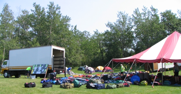
It was approaching noon when we rolled into Lake Metigoshe State Park. There was an arch to ride through, lined with a soaker hose spraying us, and people handing out lemonade and bags of treats and Freezees. The usual followed: finding and hauling bags, setting up the tent, showers in a great newish facility, hanging out, etc., etc., etc.
Supper was in the dining hall--all-we-could-eat ham sandwiches and salad, and
a very special treat: Juneberry ice cream! I didn't know such a thing existed.
![]() (As a kid, I remember picking June berries from the bushes behind
our house and getting to eat them with a little sugar on them.) We ate with
Allan and Sarah and a couple of other familiar faces.
(As a kid, I remember picking June berries from the bushes behind
our house and getting to eat them with a little sugar on them.) We ate with
Allan and Sarah and a couple of other familiar faces.
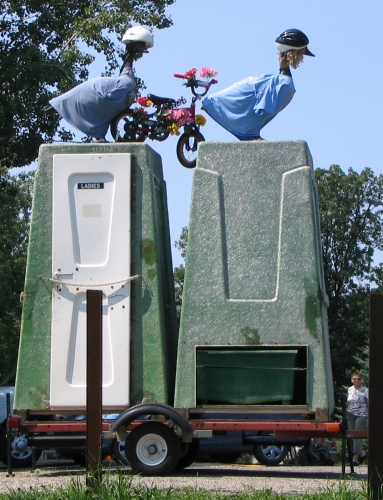 That evening, we took a walk over to the Metigoshe shoreline where there was
going to be a water ski show. We were facing west, into the setting sun, and
the setting sun reflecting off the water, so we decided to keep walking. On
our way back to Tent City, we ended up at Rory's outpost. He's the official
CANDISC mechanic and "holds court" each evening while fixing bikes. We got in
on a few stories from others and headed back to sit outside our tent.
We were on a main drag and had several people stop and chat, including a couple
more from this morning's draft party. And then, "Are you Jeff?" I certainly was!
And asking was Bill Abeling. We'd exchanged emails but had never met until
now. It was good to put a face to his name. Two years earlier, after the
CANDISC featuring the severe storm we rode through west of Mott, I'd sent an email
to the National Weather Service in Bismarck to see if they by chance had a radar
video of that storm. The fellow who replied said they didn't, but a co-worker of
his had been on that ride and wondered if I'd mind if he contacted me. Heck no!
It was Bill. And a friend of his did put together a radar video for me and sent
that along.
![]()
A food note: The June berry ice cream went down really easily, but so did the egg salad sandwich in Souris!

| Home | Return to Summary | Previous day | Next day |