CR
Planning, Inc.
2634 Vincent Avenue North
Minneapolis, MN 55411
612-588-2637 - fax
612-588-4904
- phone
www.crplanning.com

Project
Partners:
University of Minnesota Deptartment of Landscape Architecture
Professor David Pitt
Professor Richard Bolan
Summary
In 2002, Jean Coleman, CR Planning, worked with the University of Minnesota Department of Landscape Architecture to develop and apply a land use planning process based on local development and environmental protection priorities. The project was funded by the Metropolitan Council to support their smart growth strategies for accommodating an additional one million people in the metropolitan area. The project provided a handbook for local governments to guide the form and location of new development while protecting natural resources.
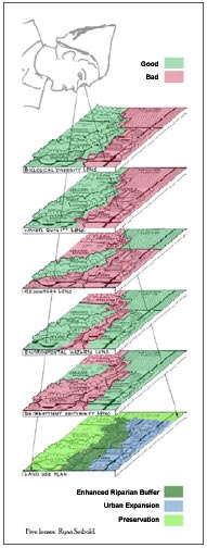
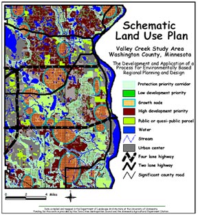
The handbook Environmentally based Regional Smart Growth Planning and Design sets forth a process for assessing local development and protection priorities. Five "lenses" are used to evaluate local green infrastructure - the network of open space, watersheds, woodlands, habitat, parks, and other natural areas that support the quality of life. Using geographic information systems (GIS) layering, the green infrastructure is assessed in relationship to urban infrastructure - roads, utilities, urbanized areas and services. This assessment incorporates community values to prioritize development and protection areas in alternative schematic land use scenarios.
The handbook also discusses the range of land use tools available to achieve development and protection priorities. Tools presented range from land acquisition to tax and financing incentives to zoning techniques such as cluster development, transfer of development rights and urban growth boundaries.
A highlight of the project is the interactive, iterative process for visualizing local environmental and development values. Using the GIS linked survey form, a community can survey residents in real time on value questions such as "How important do you think it is to guide future development patterns toward areas that will enhance protection of surface water quality?" Alternative schematic land use maps are instantly generated to reflect local values for various resources.